Build Planet Earth
Creating a model of planet Earth offers students an engaging, hands-on approach to understanding our world's geography, structure, and ecological systems. This educational activity combines art, science, and spatial reasoning while allowing learners to explore everything from tectonic plates to climate zones. Whether you're working with elementary students discovering continents for the first time or middle schoolers studying Earth's layers, building a physical representation of our planet transforms abstract concepts into tangible learning experiences. Teachers and home educators can adapt this project to various skill levels and curriculum objectives, making it a versatile addition to any science or geography unit.
Understanding Earth's Structure Through Modeling
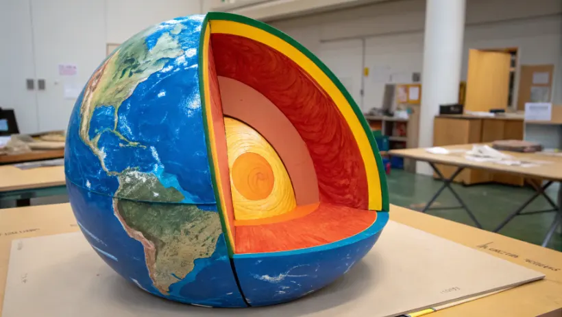
Before students begin construction, they need foundational knowledge of what makes Earth unique among planets. Our planet consists of distinct layers, each with specific characteristics that support life and drive geological processes. The inner core, outer core, mantle, and crust work together as a dynamic system that shapes continents, oceans, and atmospheric conditions. When building a model, students must consider how to represent these invisible internal structures alongside visible surface features.
Materials and Scale Considerations
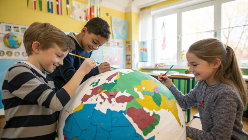
Selecting appropriate materials depends on your project goals and available resources. Paper mache over a balloon creates an affordable, lightweight sphere perfect for painting continents and oceans. Styrofoam balls offer a smooth surface for detailed mapping but require special paints and adhesives. Clay or modeling compound works well for showing three-dimensional features like mountain ranges and ocean trenches. For cross-section models revealing Earth's layers, consider using different colored playdough or foam sheets that students can stack and cut to display internal structure. Scale becomes important when deciding which features to emphasize—a classroom globe might focus on political boundaries while a geological model highlights plate tectonics.
Incorporating Geographic Features
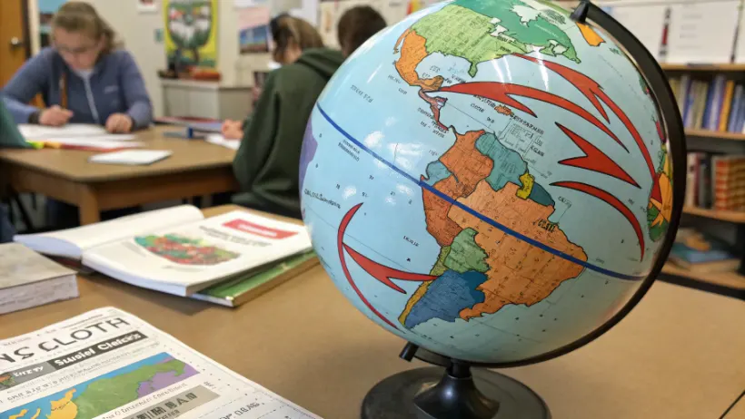
Accurate placement of continents, oceans, and major landmarks turns a simple sphere into an educational tool. Students should reference maps and globes to position the seven continents correctly, paying attention to relative sizes and shapes. Adding texture brings the model to life—raised areas can represent mountain ranges like the Himalayas or Andes, while depressed regions show ocean basins. Some educators have students mark significant locations such as the equator, Tropic of Cancer, Tropic of Capricorn, and prime meridian using string or thin wire. This geographical precision helps learners develop spatial awareness and understand how Earth's features relate to climate patterns, population distribution, and historical events.
"Hands-on modeling activities increase retention rates by up to 75% compared to lecture-based instruction, particularly in spatial sciences like geography and geology."
Educational Approaches and Learning Objectives
Building planet Earth serves multiple curriculum standards across grade levels and subjects. The project naturally integrates science, mathematics, art, and social studies while developing fine motor skills and attention to detail. Teachers can structure the activity around specific learning goals, whether that's mastering continent names for younger students or understanding plate boundary interactions for older learners. The tactile nature of construction helps kinesthetic learners who struggle with traditional textbook approaches, while visual learners benefit from seeing abstract concepts take physical form.
Adapting Projects by Grade Level
Elementary students might create simple painted globes focusing on continents versus oceans, labeling major bodies of water and landmasses. This introduces basic geography vocabulary and develops map-reading skills. Middle school projects can incorporate more complexity—showing tectonic plate boundaries with colored tape, marking major cities and rivers, or demonstrating how Earth's tilt causes seasons by positioning the model on an angled axis. High school students might tackle advanced concepts like creating relief maps with accurate topography, building cutaway models showing crustal thickness variations, or even constructing models that demonstrate magnetic field lines or atmospheric layers.
Cross-Curricular Learning Opportunities
| Subject Area | Learning Objective | Model Feature | Assessment Method |
|---|---|---|---|
| Geography | Identify continents and oceans | Accurate landmass placement | Labeling quiz |
| Geology | Understand Earth's layers | Cross-section display | Layer identification |
| Mathematics | Calculate ratios and scale | Proportional sizing | Measurement verification |
| Environmental Science | Map climate zones | Color-coded regions | Climate pattern explanation |
| Art | Develop painting techniques | Surface decoration | Visual presentation quality |
Each subject connection deepens understanding while showing students how different disciplines intersect in real-world contexts. Math skills apply when calculating how much to reduce Earth's actual diameter to fit a desktop model. Art techniques matter when mixing blues and greens to accurately represent ocean depths and forest coverage. Scientific thinking guides decisions about which features to emphasize based on the project's educational purpose. This interdisciplinary approach mirrors how professionals in fields like cartography, urban planning, and environmental science must draw on multiple knowledge areas.
Advanced Techniques and Extension Activities
Once students master basic Earth models, numerous extension activities can deepen their engagement and understanding. Some classes create multiple Earths showing different data sets—one displaying population density through color coding, another showing climate zones, and a third indicating biomes or natural resources. Comparing these models side-by-side reveals patterns and relationships that aren't obvious from maps alone. Other extensions include building models of other planets for comparison, creating time-lapse series showing continental drift over millions of years, or constructing transparent models with removable sections to explore internal structure.
"Project-based learning in Earth sciences shows a 40% improvement in long-term knowledge retention compared to traditional testing methods, with students better able to apply concepts to new situations."
Technology Integration Options
Modern classrooms can enhance physical model building with digital tools and resources. Students might photograph their completed models and annotate them using presentation software, creating virtual tours of Earth's features. QR codes attached to different regions can link to video content about specific ecosystems, geological events, or cultural information. Some educators have students use satellite imagery from NASA or NOAA to verify their models' accuracy, then make corrections based on real data. Three-dimensional printing offers another avenue—students can design digital Earth models showing specific features like ocean floor topography or continental shelf boundaries, then print small-scale versions for study and comparison.
Assessment and Presentation Strategies
- Peer evaluation rubrics where students assess each other's models for accuracy, completeness, and presentation quality
- Written reports explaining construction choices, challenges encountered, and lessons learned about Earth's systems
- Oral presentations where students use their models as visual aids to teach classmates about specific topics
- Photo documentation showing the building process from initial planning through final product
- Comparative analysis essays discussing how creating a physical model changed their understanding of geography concepts
- Museum-style displays with written placards explaining significant features and their real-world importance
- Interactive demonstrations where students manipulate their models to show processes like day-night cycles or seasonal changes
These assessment approaches move beyond simple grading to emphasize reflection, communication, and knowledge application. When students must explain their work to others, they develop deeper understanding of the content while building presentation skills. Documentation requirements encourage metacognition as learners consider what worked well and what they might do differently next time. Group projects add collaborative elements, teaching students to delegate tasks, combine different strengths, and create something more impressive than any individual could produce alone.
Long-Term Display and Educational Value
Well-constructed Earth models serve as ongoing teaching tools long after the initial project concludes. Displayed in classrooms or libraries, they prompt questions and discussions throughout the school year. Teachers reference them during related lessons about weather patterns, natural disasters, or human migration. Students revisit their work to add new information as they learn more—perhaps marking earthquake zones after studying seismology or adding endangered species habitats during ecology units. This iterative approach reinforces that learning is cumulative and that models can evolve as understanding deepens, much like scientific knowledge itself advances through continued observation and research.
Building planet Earth transforms geography and geology from abstract subjects into tangible, memorable learning experiences. Through careful planning, creative construction, and thoughtful integration across multiple subjects, this hands-on project develops spatial reasoning, scientific thinking, and artistic skills while fostering genuine curiosity about our world. The finished models serve as lasting educational resources that continue teaching long after completion.